|
“Africa and remote sensing are not for sissies” |
|
South African Synthetic Aperture Radar II
|


|
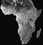
A SAR image Africa as viewed from space….the little bit off the side is Madagascar. |
|
Home |
|
The SASAR II radar system is an X band (3cm) high resolution imaging radar that makes use of Synthetic Aperture (SAR) theory to generate high resolution images of terrains from a moving platform. The SASAR II project was commissioned by a consortium of companies, namely, SunSpace, Kentron and the Radar Remote Sensing group (RRSG). The aim of the project was to demonstrate South Africa’s capabilities of developing a high resolution X-band imaging radar. The radar system itself consists of various interleaving sub-systems. The correct operation of each sub-system is critical to the success of the complete system. In order to ensure the appropriate amount of attention was given to each unit, various sub-systems were set as masters dissertations. The SASAR II is currently being integrated and tested as part of an ongoing masters dissertation, by Georgie George. A partially working radar system is expected by the end of the current year. The information presented in this website serves to give a brief description of each sub-system. The in-depth operation of a radar system, or of SASAR II will be omitted.
Please email me for further information, or references. |
|
UCT Radar Remote Sensing Group http://www.rrsg.uct.ac.za
021 650 3756 (Phone) 021 650 3465 (Fax)
|
|
Contact us |


